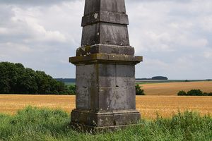
'Pyramide de Verlée' in Havelange, Belgium
Verlée is a small Belgian hamlet near Brussels. Leaving the hamlet, an unexpected stone obelisk appears in the open countryside. This obelisk stands on a ridge, lacking any explanatory signs or inscriptions. Carved garlands suggest it dates to the early 19th century, during the Empire period. Despite its prominence, its origin remains a mystery online, leading to its nickname "Belgium's only pyramid." A popular theory posits it was a topographical landmark for Colonel Jean-Joseph Tranchot's survey, but this is disproven by preserved maps. The monument's enigma is heightened by a crucial overlooked detail. Historical maps reveal a lost castle, the Château de Bouillon, situated northeast of the obelisk. The road to the obelisk aligns with the axis between the castle and the monument, with one side of the obelisk precisely aligned. This indicates the monument marked the end of the castle's axis, a feature found in grand European estates. Such monument placements, originating from Versailles, were used when a full monumental axis was impractical. Therefore, the so-called "Belgium's only pyramid" was simply a garden feature of a demolished castle.